
2024-12-31
Coastal Bridge Safety Survey: Enhancing Surveying Efficiency by Lixel L2 Pro
Intro :
Discover how XGRIDS' L2 Pro handheld LiDAR scanner and LixelStudio streamlined the surveying process for a 4.3-kilometer coastal bridge. By enabling precise navigation element measurements, this solution significantly improved operational surveying efficiency and safety in maritime channels.
The cross-sea bridge is an important transportation hub connecting cities. A certain bridge in east Asia is about 4.3 kilometers long. In order to ensure the safety of ships in the channel below the bridge, it is necessary to measure the navigation elements of the bridge to provide accurate basic data for channel management.
Commissioned by a survey and design company, XGRIDS partner Jingdao Information Technology Co., Ltd. went to the site to use the Lixel L2 Pro handheld 3D laser scanner to collect point cloud data for bridge scale analysis.
Client Overview
The project involved a bridge safety monitoring organization specializing in maritime infrastructure surveying and inspection. Their expertise includes ensuring navigation safety under large-scale bridges and providing precise structural data for engineering assessments.
Challenges/Problems:
Due to the geographical location and the particularity of the project, this project faces a series of environmental and technical challenges.
01 Continuous scanning of 4.3 kilometers at sea
In order to avoid stitching errors caused by multiple scans, this project requires continuous scanning of the 4.3-kilometer bridge cross-sea section at one time, and the continuity and stability of mobile scanning must be ensured.
02 Due to the influence of tides, the scanning time is limited
The project requires the scan of complete bridge caps, but due to the susceptibility of anti-collision facilities to tides, the scan must be completed within one hour.
03 Weak texture area scanning is difficult
Every two piers of the bridge are about 150 meters apart. The bridge is made of smooth cement slab material, which belongs to the few feature points and featured texture areas, posing a challenge to the scanning operation of LiDAR scanners.
Solution Overview
Technologies/Products Used:
The project utilized the XGRIDS Lixel L2 Pro handheld LiDAR scanner, equipped with real-time modeling and precise navigation capabilities, alongside LixelStudio post-processing software for automated data processing and model generation.
Implementation Process:
1. Real-time scanning and modeling equipment - Lixel L2 Pro:
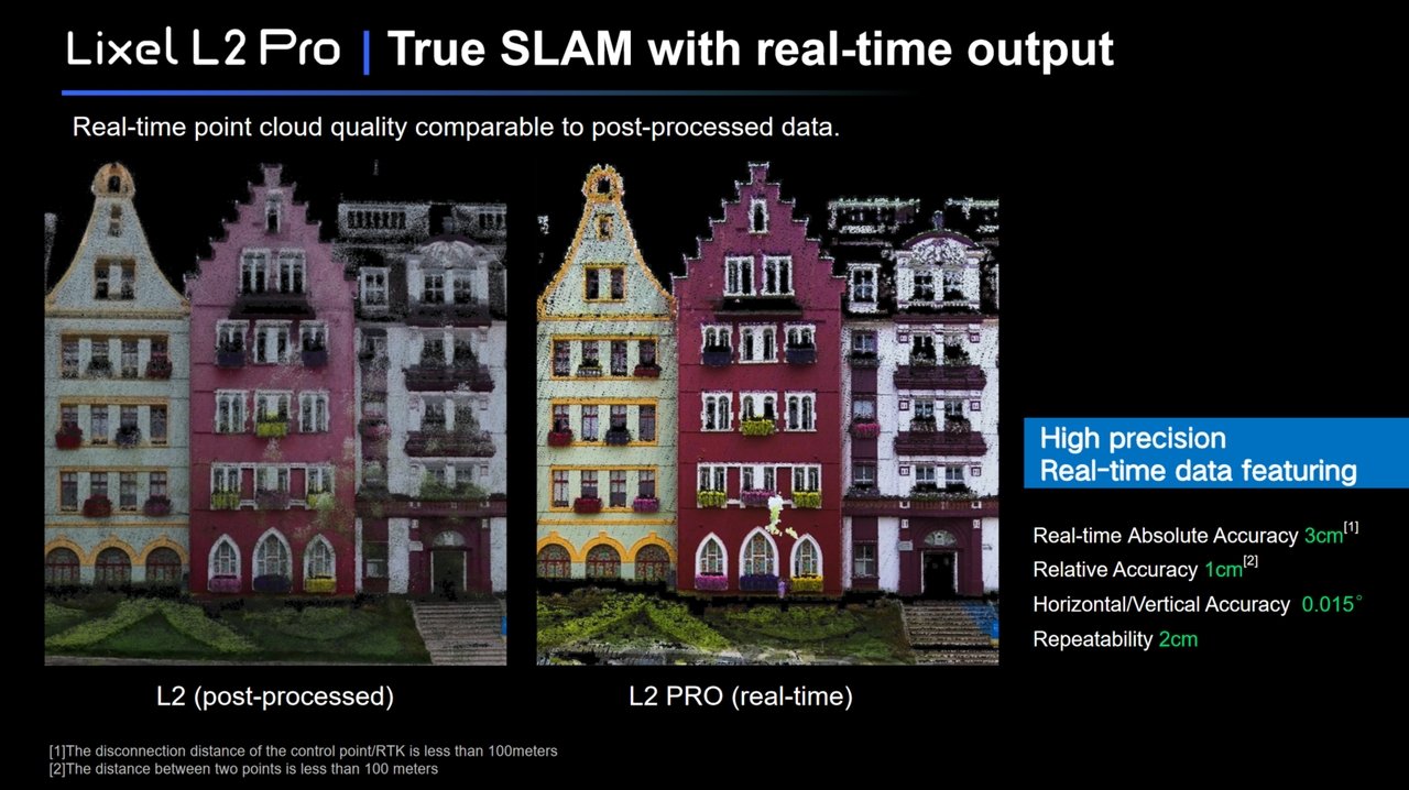
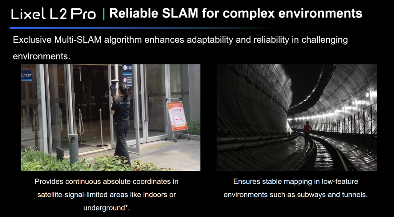
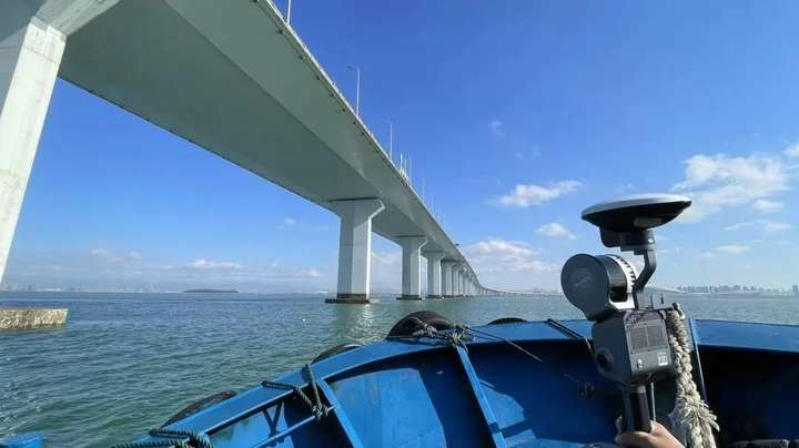
Using the L2 Pro scanner (32 channels/120 meters) from a boat, the team captured detailed 3D data of the bridge structure and navigation elements beneath it. The scanner's LiDAR + vision Multi-SLAM technology ensured accurate data collection, even in feature-sparse areas between bridge piers. It brings real-time point cloud effect comparable to the previous generation post-processing, with real-time absolute accuracy up to 3cm.
2. Completed bidirectional scanning in 02-53 minutes
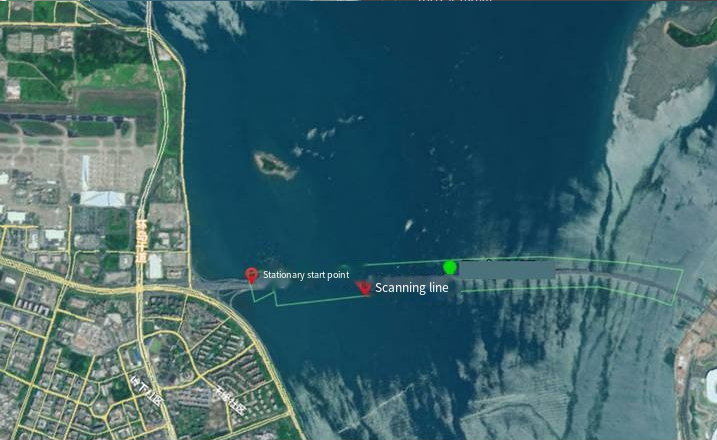
Using map software to plan the scanning route, the ship starts at a fixed position, and the scanner locates in real-time through RTK to ensure data accuracy.
Complete static initialization on the pier, after scanning starts, first scan the complete point cloud around the pier, and ensure that the scanner's perspective does not leave the pier when boarding.
After obtaining the fixed calculated result, RTK starts scanning along the vertical direction of the bridge deck at a speed of about 2-2.5 m/s. The data can be viewed in real time during the scanning process to ensure the quality of the point cloud. After the end, return to the starting point to complete the mobile scan.
The whole process only took 53 minutes to complete the bi-directional scanning of the bridge body, obtaining bridge data with a length of 4.3km, and the remaining power of a single battery is 60%.
3. Directly output point cloud data for on-site analysis
Lixel L2 Pro directly outputs point cloud data with absolute coordinates. After scanning, there is no need for additional modeling, the measurement and analysis can be completed on site.
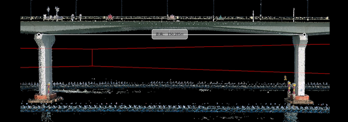
Measure key information such as bridge navigation hole height and width, bridge bottom elevation, and the safe heights through point cloud, then compare the data with documented bridge 2D drawings, and output analysis report.
The output data was directly compared with CAD drawings to assess navigation element compliance, ensuring actionable insights for maritime safety.
Results and Benefits
In this project, the Lixel L2 Pro demonstrated extremely high stability and accuracy, ensuring the quality of work; at the same time, the real-time data that can be directly exported brings a visualized and lightweight workflow, greatly improving work efficiency.
Both high efficiency and stability
Completed the two-way scanning of 4.3 kilometers of bridge within 53 minutes, efficiently delivering within a limited time.
Excellent performance in long-distance and scenes of few features and textures
Even in challenging scenarios such as long distances and feature-sparse scenes, the performance of the Lixel L2 Pro is very stable, without problems such as point clouds drifting, layering, and misalignment, ensuring the integrity and accuracy of the data.
Point cloud real-time direct available
The Lixel L2 Pro can output point cloud data with absolute coordinates in real time, and the point cloud is of high quality. Verification and accuracy check can be completed on site, avoiding the need for multiple scans due to data quality issues in traditional scanning methods, saving time and labor costs.
Customer Feedback
The customer said, 'Before L2 Pro, I have also tried other products on the market. L2 Pro did not have the same problem of layering or point cloud loss as similar SLAM products, far exceeding expectations.'
Through the efficient and accurate scanning of Lixel L2 Pro, the survey work of the bridge was successfully completed, providing reliable basic data for the navigation safety of the bridge.