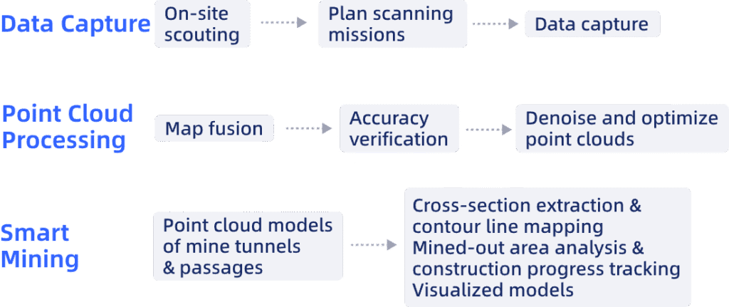
Smart Mining
Build detailed digital twins of surface and underground mines for precise measurement, simulation, and intelligent lifecycle management, improving safety and decision-making.
Application Scenarios
Tunneling & Excavation: Create precise 3D models of mine tunnels to optimize routes, prevent collisions, and calculate excavation volumes down to the centimeter.
Mine Safety Management: Monitor rock stability and ground deformation in real time, identifying potential hazards before they develop into critical failures.
Production Planning: Calculate exact volumes for excavation planning and optimize equipment deployment based on precise 3D terrain data.
Slope Stability Analysis: Track movement patterns in open-pit mine walls, providing early warnings before visible failures occur.
Tailings Dam Monitoring: Assess structural integrity continuously to detect subtle deformations that could lead to catastrophic failures.
Challenges Addressed
Replace slow, labor-intensive manual surveys with rapid, automated data capture, significantly reducing time spent in large mining areas and simplifying complex data processing.
Overcome accuracy limitations caused by environmental factors like dust and vibration, which often lead to accumulated errors in traditional surveying methods.
Generate comprehensive 3D models that provide a complete visualization of the mine, addressing the limitations of single-perspective data and enabling accurate measurement of hidden or complex areas.
Remove personnel from hazardous survey environments, such as high slopes and mined-out areas, mitigating risks associated with geological hazards and equipment failures.
Enable real-time monitoring of dynamic mine changes, providing up-to-date data for timely and informed decision-making, which is lacking in traditional, static survey approaches.
The XGRIDS Advantage
Efficiency
Achieve 5 to 8 times faster data collection with a portable, single-operator system, even in complex environments.
Ease of Use
Capture real-time, true-color point clouds with "what you see is what you get" accuracy, powered by advanced Multi-SLAM for precise point cloud colorization.
Quick Data Processing
Streamline data processing with map fusion and data synchronization from multiple sources, and rapidly generate detailed maps and profiles with one-click RCP export.
Actionable 3D Data
Integrate and reuse rich 3D models with clear textures and accurate real-world representation.
Hardware
Lixel L Series
High-Precision 3D Scanner
Learn More >
Lixel K Series
Compact 3D Scanner
Learn More >
Software

LixelStudio
Point Cloud Studio
Learn More >
Workflow